- 63:25 h
- 225.50 km
- 6,259 m
- 6,343 m
- 55 m
- 495 m
- 440 m
- Start: Hann. Münden
- Destination: Porta Westfalica
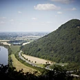
A hike on the Weserbergland Path (XW) is an unforgettable experience at any time of the year. Over 225 kilometers, the hiking trail marked with a blue XW on a green background winds along romantic castles and palaces, historic old towns, mythological figures, and vibrant raised bogs and right through the Solling. The special thing: You can expect not only a wealth of breathtaking viewpoints in the Weser valley but also a route partially directly along the Weser.
The path is considered a insider tip among outdoor enthusiasts and thus makes a hike possible where you are on familiar terms with nature. Additionally, it scores with new quality standards. Since 2012, the Weserbergland Path has been certified as a Quality Trail by Wanderbares Deutschland.
So then: let's go! Discover the Weserbergland on foot.
Please note: In Hann. Münden, the suspension bridge at the Weserstein had to be closed. To access the Weserbergland Path, go over the Pioneer Bridge and from there onto a path that merges into the XW. (As indicated on the map.)
Stage 3: Due to the wind power construction site, a detour is signposted above Gieselwerder. The Trumbach valley is temporarily not passable via the XW, and entry via Gieselwerder (Mühlenplatz parking lot) is not possible.
Good to know
Pavements
Best to visit
Directions
The 225-kilometer-long Weserbergland Path leads in 13 stages from Hann. Münden to the Weser breakthrough through the low mountain range into the North German Plain in Porta Westfalica.
The hiking trail runs once from south to north through the entire namesake holiday region Weserbergland, right in the middle of Germany. The stages are only suggestions and can of course be shortened or extended depending on hiking experience and fitness.
For athletically ambitious hikers, shortening to 6-7 stages is recommended, for example.
Equipment
Sturdy footwear is assumed. In summer, you should supply yourself with sufficient water.
Directions & Parking facilities
Further information is available from local tourist information centers and in our interactive map.
Additional information
Literature
Service booklet: The Weserbergland Path, with map excerpts, route description as well as hotel and gastronomy tips. Available free of charge at http://www.weserberglandweg.de
Organization
Weserbergland Tourismus e.V.
License (master data)
Weserbergland Tourismus e.V.
Author´s Tip / Recommendation of the author
Take the time to explore the historic towns along the route.
Safety guidelines
In some places, good sure-footedness is required. Divide the path into stages according to your strength. When wet, some sections can be slippery.
Map
Map "Weserbergland Path", current route guidance, access paths, and other forest and hiking trails, dimensions: 11 x 18.5 cm, paperback (TB), German, scale: 1:50000 Publisher: Kompass ISBN 978-3-85026-861-5
Interactive map "The Weserbergland Navigator", digital route guidance, elevation profiles, and GPS tracks. Here is the link to the Weserbergland Navigator.
Our recommendations
Nearby


