- 0:50 h
- 3.27 km
- 22 m
- 22 m
- 317 m
- 339 m
- 22 m
- Start: Hiking parking lot Langenfeld
- Destination: Hiking parking lot Langenfeld
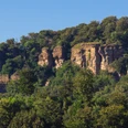
Since the battle between Widukind and Charlemagne's army in 782, the deeply incised valley on the west side of the Hohenstein has been known as the "Totental". The stream that flows through the Totental valley is also named "Blutbach" (blood stream) to commemorate this event, as it is said to have dyed the stream blood-red at the time. Today, the landscape around the Blutbach is friendly. Hikers who visit this historic area in spring can enjoy the blooming yellow and white wood anemones.
Walk: around the Totental valley
Walk: around the Totental valley
Waypoints
Start
Destination
Good to know
Best to visit
suitable
Depends on weather
Directions & Parking facilities
Wanderparkplatz Langenfeld
Contact person
Zweckverband Touristikzentrum Westliches Weserbergland
Marktplatz 7
31737 Rinteln
Author
Zweckverband Touristikzentrum Westliches Weserbergland
Marktplatz 7
31737 Rinteln
Organization
Zweckverband Touristikzentrum Westliches Weserbergland
License (master data)
Zweckverband Touristikzentrum Westliches Weserbergland
Map
Our recommendations
Nearby
